As a kid and teenager, most of my years were spent growing up in the Seattle area. I was born in Alaska and spent time there as well, camping & fishing with my grandparents into my early teens. So for me, the mountains, water & forests of the northwest have always been my favorite scenery. Although, I haven't lived in the Seattle area for 30 years now, it always feels like coming home when I visit. Seeing Mt. Rainier is always a part of that feeling. Funny thing is, I had never "been" there (largely because most of my driving years were spent in California). So this year I put it on the list of road trips.
My mom lives in Gig Harbor (near Tacoma) so there is always a good reason to cross the state. In July, aVOL2 (Julie) had several VR members coming for visits, so she had thrown out the lunch invites for any who could make it. The weather was good, the mountain roads were clear and I had a free weekend -- so I called Julie and told her I would make a special trip over to have lunch. And I called my mom and told her I wanted to slip over for a visit. Then I got out my maps and planned my trip.
For the trip over to Gig Harbor, I hopped on the interstate out of Spokane to Ellensburg. From there I found a nice alternate route off the highway, through the Yakima Canyon, south to Yakima and Highway 12. I made a short pit stop at a fruit stand to pick up a large bag of local Bing Cherries (an absolute must -- mmmm, so much better than the ones at the grocery store). From there I took Highway 410 which enters Mt. Rainier National Park at Chinook Pass, then skirts around the mountain and around the north side of the park. I didn't take many pictures on the way over, but 410 is an enjoyable, scenic road. God bless the Washington Highway Dept. -- with the exception of stretches of I-5 & I-90, there are few straight stretches of road in this state!

Looking towards Chinook Pass on Highway 410.
The entrance to Rainier National Park at Chinook Pass.
The view of Mt. Rainier from Chinook Pass.
The other side of Chinook Pass.
When I reached the flatlands again, I pulled over to take a break and have a snack. A fox darted into the trees, but after a moment of sizing me up from the cover of the trees, he rejoined me to soak up a little sun and watch the traffic.
The mountain creates a scenic backdrop while traveling through the Enumclaw-Bonney Lake area. As the sun sets, the mountain turns shades of purple and pink. Time to call mom and have her start dinner -- be in Gig Harbor soon.
The weekend that I travelled over, one of our VR members, C.O.Tude, was visiting some family in Seattle. Seemed like a good reason for a ride and some food, so a few of us met C.O.Tude and his family for lunch on the Tacoma waterfront. Julie brought her t-shirts and sharpies, of course, as well as a couple spare Ronnie Rally shirts. The extra Ronnie Rally shirts were for a couple ailing brothers, Highway Thunder & Alberta Rider, who both missed the Ronnie Rally while battling cancer. We each signed the shirts, before they were sent off to other states to make the rounds. In August I was in Alberta, and got to ride with Warren (Alberta Rider) the weekend we gave him the shirt. (Picture: from left, Julie, C.O., his wife and family, Jim, myself, DanEBoy's wife)
A beautiful day down on the waterfront. Julie poses with her two favorites...lol...myself & Jim (vol210).
DanEBoy comes out from behind the camera and joins Jim & I for the last shot.
After lunch, we confirmed the "Seattle tourist oath" with C.O.Tude. While here, he was free to enjoy the blue skies, warm weather and beautiful scenery so long as he agreed that once he left, he would tell everyone it rained every day he was there. I rode with Julie from Tacoma, back to her house. From there I headed off to see grandma, who lives near Julie.
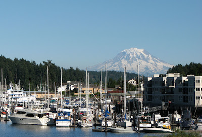
Gig Harbor with Mt. Rainier in the background. A nice day for a ride around the area!
A view of the Puget Sound from Gig Harbor.
The Tacoma Narrows bridges, a few miles south of Gig Harbor, with the Olympic Mountains in the background. The bridge on the left is new and was just recently completed.
One of the local residents.
After a weekend of visiting family and friends, it was time to head for the hill.
Passed this interesting place on the road into the park. Didn't stop this day, but might have to check it out on a future visit. Lots of cool scrap iron sculptures in the yard and a shop in back.
My trip into the park began at the Nisqually entrance at the southwestern corner of the park. The two major visitor centers, with views of the mountain, are at Paradise and Sunrise. I visited Paradise first, then travelled east to 123, where I actually headed south out of the park for lunch and fuel. I returned north on 123/410 to Sunrise, and then backtracked, exiting the park at the Stevens Canyon area and then taking Highway 12 eastbound to head home. Could have saved a little time by exiting the east entrance and taking 410 over the Chinook Pass -- but, that was the way I came over. Rather take a different route when possible, and didn't mind a little more time in the park. The scenery was certainly worth another look.

Entering the park, the lush forest is a bit reminiscent of my ride through the Redwoods.


Kautz Creek. Judging by the width and rocky nature of the riverbeds throughout the park, the spring runoff must be quite impressive. Flows are pretty minimal during my visit. A few years back, the park experienced some severe weather and heavy flooding that caused a lot of damage. If I remember correctly, the mountain received 16" of rain in one 24 hr period. I believe Kautz Creek actually changed course during the flooding and the main flow no longer travels through this creekbed.
The Nisqually Valley.
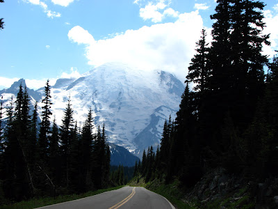
The south face of Mt. Rainier, from a viewpoint heading to Paradise.
A few zoomed in shots of the glaciers and face of the mountain.

Looking down on Narada Falls.
A view from the road.
Crossing the Nisqually River.
I stopped to take a stroll in dry riverbed. Can you spot the people?
A portion of the view at the Paradise Visitor Center.
While putting this together, it ocurred to me I had a program to merge photos which I had never tried out. I didn't take the photos with this in mind, but Photostich did a pretty good job of merging them into a wide panorama.

A zoomed in shot of the glaciers.

A group of folks preparing for a more intimate interaction with the scenery. I considered a short hike, but actually most of the trails in the area were still closed, or covered in snow, or muddy from the melt.
 Another shot, as I backtracked back down from Paradise.
Eastbound from Paradise, stopped briefly at the Reflection Lake pullout.

The ride east to Hwy 123 was spectacular, traveling along the canyon edges with fantastic views.

Sometimes Mother Nature gets pretty serious. Imagine most of these downed trees were a result of the flooding in 2006.


I stopped for a short hike through Box Canyon.

Looking down at the creek in Box Canyon.

A view of Mt. Adams, in the distance, from Box Canyon.
A short distance before you reach Sunrise Visitor Center, there is an incredible lookout point, with probably the most spectacular views in the park.
A sign at the lookout that labels nearby peaks and discusses the formation of the mountains.


A view of Mt. Adams to the south.
Another Photostich panorama.

Looking to the north from the viewpoint.
An alpine lake below the viewpoint.
The alpine meadow at Sunrise. Nice day for a hike up to the ridge.
A relatively easy hike, but the boots and leather jacket quickly feel heavy for hiking.

 A Photostich panorama of the view looking down from the ridge above Sunrise.
 The view of Sunrise Visitor Center from up on the ridge.
 The view of the NE face of Mt. Rainier from the ridge above Sunrise.
The views looking off the other side of the ridge weren't bad either.
 Mt. Baker to the north, from the ridge at Sunrise.
A shot from the saddle, as I descend from Sunrise and head for home.
The White River.
The final view of Mt. Rainier, on Highway 12, near White Pass.
Heading home I took Highway 12 to Yakima (and stopped for more cherries!) and then travelled through the Yakima Canyon again to Ellensburg. Came across a herd of about a dozen Bighorn Sheep on the move across the hillside.
The sun was setting as I reached the interstate at Ellensburg, silhouetting the jagged peaks of the Cascades and Mt. Adams on the horizon.
As the sun set on the desert, a near-full moon was rising.


